Land Survey and Transportation Design

OVERVIEW
Land Surveying is the measurement and mapping of our surrounding environment using mathematics: chiefly geometry, trigonometry, regression analysis; physics; engineering; metrology, and programming languages.

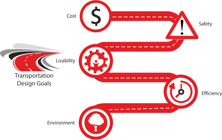
Transportation Design is the geometric design of roads that aims at optimizing efficiency and safety of people and goods on the move; minimizing the transportation cost and damage to the environment, and enhancing 'livability'. It involves the design of ingress and egress of vehicles, study of traffic volumes and capacity analysis.
Employment
Land surveyors and transportation designers work mostly for government departments and infrastructure companies. However, as surveying and road design is an integral part of any construction work, they are employed in construction firms where they act as consultants to civil engineers.
The Role of CAD
With CAD software, surveyors can streamline projects and evaluate multiple what-if scenarios. They can more easily weigh environmental constraints, aesthetic concerns, and construction costs. CAD helps surveyors to enrich the design process using visualization and simulation tools that give the stakeholders a better understanding of a site. In short, they can quickly and easily create, annotate, move, rotate and plot and generate land surveying drawings.
In transportation design, CAD is used to evaluate existing conditions of transportation infrastructure and generate data-rich proposals, design, and document.
Course Syllabus
-
MX Road
Overview :
MX Road is an advanced string based modeling tool that enables the rapid and accurate design of all types of roads.
It is widely used by civil engineers, designers, professional surveyors, geotechnical engineers, storm drainage/water/sewer system designers and civil engineering consultants.Why should you learn?
MX Road is a proven, powerful, and concise method of creating any 3D surface. It automates much of the design detailing process, thus saving your time. You can quickly find design alternatives to achieve the ideal road system
Learning Objectives :
At CADD Centre, we help you master some of the following features of MX Road:
- Interoperable database - creation and annotation of 3D project models in popular CAD
- Digital Terrain Model creation and analysis
- Integration with Google Earth
Learning Outcome:
- You will learn how to design 2D, 3D drainage design
- You will know how to automate production of contract drawings
- You will learn to design storm drainage, water/sewer system
-
MicroStation
Overview :
MicroStation is the world’s leading information modeling environment explicitly for the architecture, engineering, construction, and operation of all infrastructure types including utility systems, roads and rail, bridges, buildings, communications networks, water and wastewater networks, process plants, mining, and more.
It helps engineers meet the demanding requirements of architectural, engineering, construction, operations (AECO), and geospatial professionals. It is ideally suited for all infrastructure types, and can be used either as a software application or as a technology platform for a wide range of discipline-specific applications from Bentley and others.Why should you learn?
It is comprehensive design, engineering, and simulation applications.
MicroStation can meet the needs of infrastructure teams across every discipline throughout design, construction, and operations. It is relied upon for speed, power, precision, and confidence by about 47 of the top 50 ENR design firms in the world. It is used in 143 countries and supports 13 languages.Learning Objectives :
At CADD Centre, we help you master the following features of MicroStation:
- MicroStation’s highly interoperable environment that ensures information from diverse sources is integrated and accessible on demand by your team, empowering the incorporation of any design data, regardless of format.
- Extensive Format Interoperability – Precise incorporation of existing data from an extensive range of AECO and geospatial formats including DGN, RealDWGTM, DXF, PDF, point clouds, U3D, 3DS, Rhino 3DM, IGES, Parasolid, ACIS SAT, CGM, STEP AP203/AP214, STL, OBJ, VRMLWorld, Google Earth KML, SketchUp SKP, Collada, ESRI SHP, IFC, and more.
- Geocoordination – Automatic transformation and integration of geospatial information supporting hundreds of geospatial coordinate systems and ensuring spatial information is always displayed in its proper context.
Learning Outcome:
- You will make the best design, construction, and operational decisions by having ready access to all of the applicable information
- You will confidently produce trusted deliverables such as precise drawings, information-rich 3D PDFs and 3D plots that enable performance simulation of designs, including lifelike rendering and compelling animations.
- You will integrate a comprehensive breadth and depth of engineering geometry and data from an unmatched range of CAD software and engineering formats
- You will build better infrastructure by accurately predicting the infrastructure’s real-world performance in advance.
- You will know how to track and report on changes made to designs down to the component-level throughout the model’s lifecycle including revision control, roll-back of changes, and visual display of historical changes.
- You will learn to design file controls to ensure that only authorized individuals can view, edit, or print designs within a user-defined time limit.
-
AutoCAD Civil 3D
Overview :
AutoCAD Civil 3D software is a civil engineering design and documentation solution that supports Building Information Modeling workflows.
It is used for designing, drafting and documentation, analysis, defining workflows, surveying and mapping of civil projects.Why should you learn?
AutoDesk’s AutoCAD Civil 3D infrastructure professionals can better understand project performance, maintain more consistent data and processes, and respond faster to change. AutoCAD Civil 3D tools support Building Information Modeling (BIM) processes and help reduce the time it takes to design, analyze, and implement changes.
Learning Objectives :
At CADD Centre, we help you master some of the following features of Civil 3D:
- Design: For corridor design, pressure pipe networks, gravity pipe networks, grading, parcel design, bridge modeling, geotechnical modeling, and rail track layout
- Analysis: For advanced mapping and analysis functionality, storm water management using dynamic model, dynamic QTO and earthwork calculations, transforming civil design models with visualization.
- Drafting & Documentation: For drafting standards, construction documentation, map production, and for reports and tables
- Surveying & Mapping: For surface modeling, base map creation, and reality capture.
Learning Outcome:
- You will know how to evaluate more what-if scenarios and optimize project performance, streamline project workflows by automating time-consuming tasks.
- You will know how to use streamlined workflow for creating corridor models, and gain mastery over tools for pressure network creation, sanitary and storm drainage systems, terrains models for grading, automated parcel layout tools.
- You will learn how to use tools for dynamic surface creation, streamline mapping and surveying workflows, and use point clouds to digitize as-built features.
- You will learn to use an extensive library of CAD drafting styles, generate annotated production plans, use cartographic mapping functionality, and use dynamic tables for linework.
- You will know how to do storm and sanitary analysis, geospatial analysis, and river analysis.
Pre-requisite
These are 80-hour certificate programmes. Students pursuing diploma and degree programmes in Mechanical Engineering can enroll in these basic CAD programmes.
Job Titles
Upon completion of the course, students can apply for the job of Draftsman / Engineer / Analyst / Product Designer / Product Engineer
Entry-level Salary
Upto Rs 3 lakh per annum (in India)
Diploma, Professional, and Master Diploma Courses
It is important for the students and professionals to gain practical knowledge and undergo training in different CAD software and software modules that come handy at different stages of designing and planning. They need a thorough grounding in project management concepts. Considering these requirements, CADD Centre has designed the following diploma and professional courses:
Diploma in Survey and Transportation Design
The diploma in Architectural Design covers various aspects of design related to survey and transportation design by introducing participants to multiple combinations of tools. This course ensures that essentials of this field such as surveying and design explorations are simplified for the participants.
Pre-requisite
These are 40-hour programmes. Students pursuing a diploma or degree course in land surveying, civil engineering, transportation (or road) design and working professionals can enroll in these courses.
Job Titles
Upon the completion of the course, students can apply for the jobs of Senior Land Surveyor / Planning Engineers / Survey Crew Chief / Senior Transportation Designer
Entry-level Salary
Upto Rs 5 lakhs per annum in India